Introduction “Kayaking in New York City”
As New York City marks its 400th anniversary, one of the most immersive ways to connect with the city’s rich history is by kayaking through the rivers that helped build it. These waterways, integral to the city’s growth, offer a unique perspective on the evolution of Manhattan from a small Dutch settlement into a bustling global metropolis.
Exploring Manhattan’s Natural Roots
As I paddled near Inwood Hill Park, Manhattan’s last remaining native forest, the usual clamor of the city faded away, replaced by the soft chirping of crickets. The roots of ancient trees clung to boulders left behind by the Ice Age, and a great blue heron gracefully swooped into the nearby salt marshes. For a moment, it felt like I had stepped back in time, witnessing Manhattan as its original inhabitants once did.
This year marks 400 years since the Dutch established New Amsterdam, a settlement that would eventually become New York City. While a celebration of this milestone is appropriate, it’s also a time for reflection on both the achievements and darker aspects of the city’s origins, particularly the displacement of Native Americans and the use of enslaved Africans to build much of early Manhattan.

New York: A City Shaped by Water
Though modern-day Manhattan may seem like a concrete jungle, its success is directly tied to its natural waterways. “It’s all about the water,” says Captain Jonathan Boulware, president of the South Street Seaport Museum. The city’s identity, growth, and cultural diversity all stem from its strategic access to the Hudson and East rivers, which connect New York to the rest of the world.
To gain a better understanding of the city’s history, I embarked on a 30-mile kayak journey around Manhattan. Over nine hours, I experienced firsthand how the rivers shaped the island and continue to be central to its story today.
The Discovery of New York’s Natural Harbor
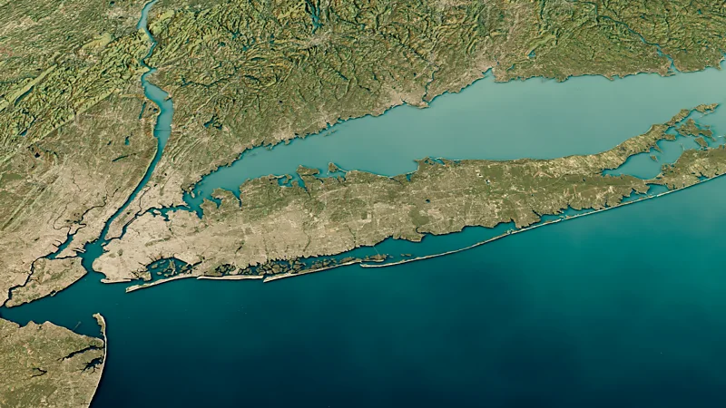
In 1609, Henry Hudson, hired by the Dutch East India Company, sailed into what is now New York Harbor while searching for a passage to Asia. Although he didn’t find the route he was looking for, Hudson discovered one of the largest natural harbors in the world. This protected bay, surrounded by Staten Island and Long Island, became a crucial entry point into the New World.
With its deep waters and extensive network of navigable rivers, Manhattan quickly became a prime trading hub. Goods such as fur, tobacco, and grain were shipped from the mainland to Europe, turning the island into a thriving economic center.
A Colony Built on Trade
The Dutch, unlike many early American settlers, were not motivated by religious freedom but by profit. Manhattan’s strategic position for trade made it a melting pot of cultures from its very inception. By 1646, the island was home to people of various backgrounds, speaking at least 18 different languages.
However, long before the Dutch arrived, the area was already a crossroads for Native American tribes like the Lenape and Shinnecock, who used Manhattan’s rivers for fishing and trading. This history adds another layer of significance to the waterways that surround the island.
The Ecological Treasure of Mannahatta
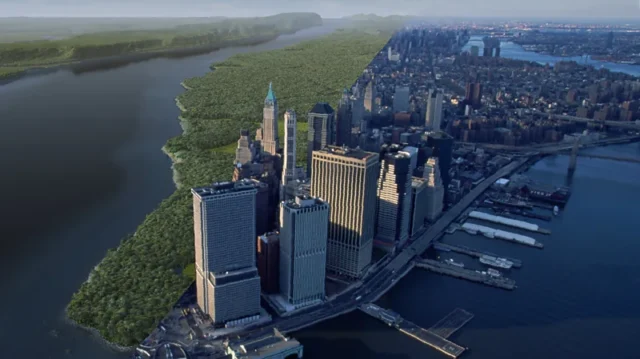
When the Dutch arrived in the 1600s, the island of Mannahatta (as the Lenape called it) was an ecological marvel. It boasted 66 miles of rivers and streams, 233 bird species, and a wide variety of ecosystems. In fact, Mannahatta’s biodiversity per acre was greater than that of Yellowstone or Yosemite.
Over time, as the British took control and the city grew, the natural landscape was transformed to accommodate New York’s booming economy. By the 1770s, New York had become the “breadbasket of the Atlantic,” exporting goods like wheat and timber across the globe. The city’s reliance on water remained at the core of its success.
The Erie Canal: Connecting Manhattan to the Nation
One of the most pivotal moments in New York’s rise as a global city was the construction of the Erie Canal in 1825. This 363-mile canal connected the Hudson River to the Great Lakes, allowing goods to flow from the interior of the United States to Europe. As a result, New York quickly outpaced other American cities in terms of trade and became the busiest port in the world.
Immigrants flooded into the city, with Census records from 1860 showing that nearly 70% of New York City’s adult population was born outside the United States. This influx of cultures and ideas helped shape the diverse, multicultural city we know today.

Rediscovering Manhattan’s Waterfront
For much of the 20th century, New York’s maritime industry declined as container ships were diverted to nearby New Jersey ports. The city’s waterfront fell into disrepair, and pollution plagued the once-vibrant harbor. However, in recent years, New York has invested billions of dollars into cleaning its waterways and revitalizing its waterfront.
Kayaking along the Hudson River today offers a striking view of Manhattan’s rebirth. The formerly derelict piers have been transformed into green spaces, parks, and cultural landmarks. One example is Little Island, a $260 million floating park that opened in 2021, blending modern design with native ecosystems.
The Current and Tides: Paddling Through History
While kayaking around Manhattan, I quickly realized the importance of understanding the island’s tidal flows. The Hudson River, whose original name “Mahicantuck” means “river that flows two ways,” changes direction every few hours due to ocean tides. The East River, though technically a tidal strait, behaves similarly.
Guides from Manhattan Kayak Co. expertly navigate these waters, taking advantage of the shifting currents to make the journey smoother. Eric Stiller, the company’s founder, recalls how he started paddling in the 1980s, when access to the water was limited, and kayakers had to sneak onto rotting piers to launch their boats. Today, kayaking around Manhattan is a much more accessible and organized experience.
The Waterfront Revival: A New Era for Manhattan’s Rivers
As we paddled along Manhattan’s western shore, the revitalized waterfront unfolded before us. The 550-acre Hudson River Park, which began its transformation in 1998, now features restored marshes, native grasses, and creative urban spaces that honor the island’s maritime history.
One standout project is Tribeca’s Pier 26, where a newly planted woodland forest and coastal grasslands mimic the area’s original ecosystems. Another example is the East Midtown Waterfront project, which is set to complete in 2026 and will provide continuous public access around the entire island.

Kayaking: A Unique Perspective of New York City
Kayaking around Manhattan is not just a thrilling adventure—it’s a reminder of the city’s deep connection to the water that surrounds it. As more New Yorkers and visitors discover this unique perspective, Manhattan is once again embracing its water-bound roots.
Whether you’re paddling past the towering skyscrapers of the Financial District or gliding by the restored marshes of Inwood Hill Park, kayaking offers an unparalleled way to experience the natural and historical forces that shaped New York City.


